
|
|
THERMAL EMISSION FROM JUPITER
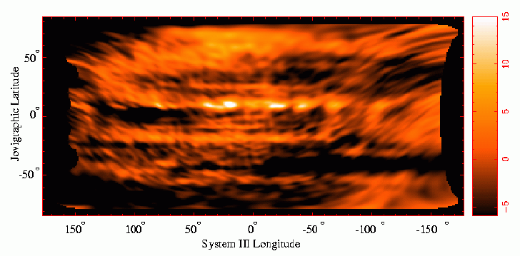
The image above is a radio `map' of Jupiter at 2cm, derived
from VLA observations taken on 25 January 1996.
The data were taken by Imke de Pater (UC Berkeley), and were further reduced
and imaged by Chermelle Engel (University of Melbourne)
and Bob Sault (ATNF). The results have been published by
Sault, R.J., C. Engel, and I. de Pater, 2002. Topographic imaging
of Jupiter at radio wavelengths. Icarus, submitted.
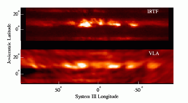
Due to the fast rotation period of Jupiter (approximately 10 hours), radio observations are rotationally smeared. Radio images are generally longitude-averaged, as the 4-panel image above. This has resulted in longitude dependant features of Jupiter remaining unobserved in radio wavelengths. In this project we produced a 2cm longitude/latitude map of Jupiter using 6 hrs of data. (see:http://www.atnf.csiro.au/research/solarsys/jupiter/thermal.html for details). Below we show a comparison with an infrared image at 5 micron, obtained by Ortiz and Orton with the IRTF telescope. (Ref:Sault, R.J., C. Engel, and I. de Pater, 2002. Topographic imaging of Jupiter at radio wavelengths. Icarus, submitted.)
(see:http://www.atnf.csiro.au/research/solarsys/jupiter/thermal.html for more details)